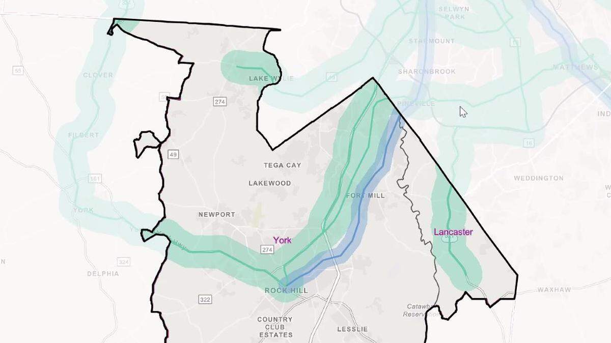
Map shows proposed mass transit routes in region, into York and Lancaster counties.
The Connect Beyond transportation group on Wednesday released a map that showed a list of high capacity mass transit corridors across the Charlotte region.
The map showed multiple corridors leading into York and Lancaster counties. One is I-77. Another is U.S. 21. Other options include possible connections in Indian Land via U.S. 521, and Lake Wylie by S.C. 49.
High capacity route options would include light or commuter rail, bus rapid transit or streetcars.
“At this point we’re not saying it’s going to be a particular mode,” said project leader Jorge Luna. “We’re just saying that the corridor is high capacity transit and there’s additional work to be done to identify what mode is the best fit for that particular corridor.”
For the study, project manager Jason Wager looked across a 12-county, two-state region, now with 2.6 million people. There will be 1.4 million more people, he said, by 2045. The Charlotte region will bring in two-thirds of North Carolina growth in that span, he said.
It’s a similar picture for Charlotte region areas south of the N.C. state line.
“York and Lancaster counties have the highest growth rates in the region,” Wager said.
Connect Beyond is an association of transportation bodies across this region. The 12-county region includes Anson, Cabarrus, Cleveland, Gaston, Iredell, Lincoln, Mecklenburg, Rowan, Stanly and Union counties in North Carolina, and the urbanized areas of Lancaster and York counties in South Carolina.
York, Lancaster transit connections
The Rock Hill-Fort Mill Area Transportation Study directs federal dollars in its two namesake municipalities, along with Tega Cay, Lake Wylie and Indian Land. When they met Sept. 25, the RFATS policy committee previewed the list released Wednesday.
David Hooper, RFATS director, said the new corridors are part of a larger message.
“Not everyone needs to be in a (personal) vehicle for every trip,” he said. “We can’t just grow unbridled and continue to think we’ll be able to keep what we have.”
Transit impacts business, experts say. Transit is an amenity for workers and something companies look for when choosing areas to do business.
“It has a direct impact on our economic competitiveness,” Hooper said.
Some York County routes on the transit map are of little surprise. Interstate 77 is the dominant transportation corridor in the area. The U.S. 21 corridor has been identified as the likeliest route for mass transit.
A route in Lake Wylie is new. A study more than a dozen years ago didn’t show demand for bus service there. So is the U.S. 521 route in Indian Land. The S.C. 5 route west toward York, then up to Clover and North Carolina is new but isn’t as immediate a priority as others on the map.
“This is viewed as long, long term because of the type of development that would have to occur,” Hooper said.
Transit plan timing
Connect Beyond is a quarter way through its 18-month planning process. A public survey will be done this month (October). In January an update will reclassify some proposed transit routes to preferred, and transit options could loop in with the Charlotte Area Transit System 2030 plan.
CATS CEO John Lewis said mass transit planning and use dates back decades in his city.
“The next natural step is to figure out how do we broaden that beyond just Mecklenburg County,” Lewis said. “How do we meet the community and mobility needs of our regional partners?”
Former Charlotte Mayor Harvey Gantt told planners on the virtual meeting Wednesday that the long-term viability of the region as a quality place to work and live depends on connectivity -- and not just in Charlotte.
“We have to deal with these kinds of things to make the region more viable for people to live in, for industries and others to come into this area,” he said. “And mobility is at the center of that effort, how we connect Charlotte to Rock Hill, to Concord, to Gastonia.”
Indian Land, Fort Mill connection
A connection that isn’t on the list now is from Indian Land to Fort Mill.
The panhandle of Lancaster County should be connected,” Johnson said.
The RFATS group discussed asking regional planners to consider bus or other options. Lancaster County council member and RFATS policy committee member Brian Carnes said there could be demand.
“We have a more concentrated flow that comes from Fort Mill and into Fort Mill (from Indian Land),” he said.
Fort Mill Mayor Guynn Savage is chair of the RFATS policy committee. She’d said she’d like to see details on whatever connection might be proposed, given Fort Mill already faces significant congestion as a midpoint between Rock Hill and much of urbanized York County, and the Indian Land or Ballantyne areas.
“We’re a pass-through in many cases,” Savage said.
Kingsley, Riverwalk, Panthers site
The U.S. 21 corridor has for at least a decade been considered the likeliest route -- particularly for rail -- if mass transit comes. It would connect the Kingsley and former Knights Stadium areas of Fort Mill with the Riverwalk and Carolina Panthers headquarters areas of Rock Hill.
Timing, funding and other major details remain unresolved, but transportation planners say the high capacity corridors could help create the spine of a network.
New transit can take years or decades, but a more recent event came up plenty in Wednesday’s conversation. The COVID-19 pandemic has cost jobs, which impacts tax and other revenue options. Lewis said the CATS system served about 75,000 riders on a typical workday prior to coronavirus. That number has dropped 80%, he said.
York County Councilman Michael Johnson said at the recent RFATS meeting he has seen reduced workweek traffic during the pandemic, and heard from large companies that may change how they do business. Some companies may hire fewer people who travel into Charlotte every workday.
“We envision a transportation future that supports our post-COVID economic activity, and provides regional connections as we think about access to jobs and healthcare and education, and local access necessary for communities to prosper,” said Michelle Nance, regional planning director with Centralina Regional Council of Governments.
Not all high capacity candidate corridors will be chosen, and not all chosen necessarily will have light rail.
“I mean anything that has more capacity than a traditional bus, such as light rail, commuter rail or express bus,” Nance said of high capacity options.
More than half the people studied in the Connect Beyond transportation study live in one county and work in another, Nance said.
“The corridors we collectively decide upon now will shape how our region grows over the next 20 years and beyond,” she said.
This story was originally published October 1, 2020 at 11:19 AM with the headline "Map shows proposed mass transit routes in region, into York and Lancaster counties.."