Hurricane Lee back to Category 4 strength, Tropical Storm Margot forms. Latest forecasts for NC
For Friday evening updates on Hurricane Lee and Tropical Storm Margot, click here.
The National Hurricane Center is monitoring two systems in the Atlantic: Hurricane Lee, which shot up to a Category 5 status late Thursday, and Tropical Storm Margot, which formed from a disturbance that’s been in the eastern Atlantic for several days.
The most immediate concern
Tropical Storm Lee dropped back to a Category 4 storm with 155-mph winds as of midday Friday, after reaching Category 5 strength Thursday night. The storm only became a hurricane on Wednesday, but as forecasters predicted it rocketed through the Saffir-Simpson Hurricane Wind Scale Thursday, reaching maximum sustained winds of more than 165 mph.
The storm gained 80 mph in sustained wind strength in 24 hours, the Hurricane Center said.
Hurricane Lee is expected to gain and lose strength Friday before dropping back to a Category 3 storm on Saturday, with maximum sustained winds of 125 mph to 130 mph. The storm could restrengthen in coming days, the forecast said.
“Regardless of exact details of the intensity forecast, confidence is high that Lee will remain a powerful hurricane during the next several days,” the Hurricane Center said.
Lee also is expected to slow its movement across the ocean, meaning it will remain a potential threat to the Southeastern U.S. coast through the end of next week.

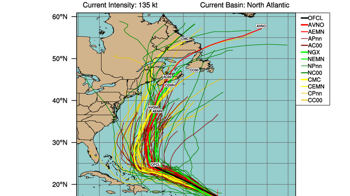
Could Lee reach North Carolina? South Carolina?
▪ Most — but not all — forecasts say the storm will veer away
Forecasters say Hurricane Lee will continue to move to the north-northwest through at least Wednesday. Long-term computer models by forecasters from around the world show the storm turning north, most of them in time for it to stay away from the Southeastern U.S. coast.
As of Friday, at least two models have the storm making the turn so late that its northward trajectory would bring it ashore in North Carolina.
The hurricane center said Friday it’s still too early to make a reliable prediction on the track of the storm into next week.
▪ Several variables will affect Hurricane Lee’s path
Whether it approaches the coast, including North or South Carolina, will depend in part on the behavior of the jet stream as well as the strength of the Bermurda-Azores High as the storm traverses the ocean. The Bermuda-Azores is a high-pressure system that circulates in a clockwise direction, pushing warm air southwesterly toward the U.S. Atlantic coast.
If the high is strong, it can steer a counter-clockwise-spinning Atlantic hurricane away from the coast.
▪ Hurricane Lee will have impacts along NC and SC even from afar
Friday morning, the National Hurricane Center said waves at the center of the storm were 45 to 50 feet, the height of the Beacon of Freedom monument in the center of downtown Raleigh’s Freedom Park.
Because of its growing size and strength, the National Weather Service said Hurricane Lee would begin to generate long-period swells — bigger, more powerful waves with longer intervals between them — along the Southeast coast starting Sunday night.
Higher than normal seas are expected through late next week because of Lee’s projected slow movement.
▪ Rip currents are a major hazard
While the bigger, stronger waves are alluring to surfers, they can generate dangerous rip currents, make ocean swimming hazardous, and they can cause beach erosion.

Tropical Storm Margot forms
A second system developed into Tropical Storm Margot Thursday night and had maximum sustained winds of around 40 mph Friday morning.
That storm should develop into a hurricane over the next few days, the National Hurricane Center said. The storm is still in the eastern Atlantic, moving to the west-northwest.
Current forecasts show Margot tracking more to the north across the Atlantic by Sunday, keeping it away from the Southeastern U.S. coast.
This story was originally published September 5, 2023 at 11:22 AM with the headline "Hurricane Lee back to Category 4 strength, Tropical Storm Margot forms. Latest forecasts for NC."
