
Freezing rain could knock out power, slicken roads for many in Charlotte region
UPDATE: As of Thursday morning, the Charlotte area is under a winter weather advisory through 7 p.m. For the latest weather information, go here.
Story from Wednesday:
Freezing rain could topple power lines and slicken roads in Charlotte and nearby communities just before the morning commute on Thursday, a National Weather Service meteorologist said.
Duke Energy said Wednesday it expects a million Carolinians to lose power during the advancing storm.
Charlotte has a 100% chance of rain moving into the area late Wednesday or early Thursday, according to the latest NWS forecast at 5 p.m. Wednesday.
The rain should arrive about midnight, or 2 a.m. Thursday at the latest, NWS meteorologist Justin Lane said. The rain could freeze in the uptown Charlotte area between 5 a.m. and 6 a.m., when temperatures are expected to be at their overnight lowest, at 33 degrees, meteorologist Ashley Pratt of the NWS office in Greer, S.C., said.
Less than 0.1 of an inch of ice is possible in Charlotte on Thursday, according to the NWS forecast. Earlier Wednesday, the NWS said little or no ice accumulation was expected in Charlotte.
Pratt said even a trace amount of ice can “cause havoc” for drivers. Black ice, or patches of ice you can’t easily see, could threaten drivers into Thursday night, she said.
The NWS said anywhere from 0.01 to 0.1 inches of ice could reach Charlotte, northern Union County and north of Rock Hill in York County, S.C.
The NWS predicts 0.1 to 0.25 inches of ice in northern Mecklenburg, western Gaston and Lincoln counties and all of Cleveland County; and 0.25 to 0.5 inches of ice in most of Iredell, Cabarrus, Catawba and Rowan counties.
Students in the Iredell-Statesville Schools will learn remotely on Thursday due to the weather threat, officials said.
“The area of most concern is the I-40 corridor and higher elevations,” according to an NWS tweet. “Trends are slightly cooler across the Charlotte Metro area.”
And because temperatures aren’t expected to climb much, any frozen stuff could linger through the morning and early afternoon, when showers are finally forecast to taper off, she said.
A high of only 35 degrees is forecast on Thursday, according to the NWS.
Watch out on bridges and overpasses
Whatever precipitation is left on surfaces, however, could refreeze on Thursday night, Pratt said.
For Charlotte, overpasses and bridges are most at risk of seeing a glaze Thursday morning from even a “trace” amount of ice, according to Pratt.
The NWS considers a trace or “negligible” amount of ice to be any amount under 0.01 inches, according to Lane.
The risk of freezing rain is higher in areas north of uptown on Thursday morning, including Huntersville and Davidson, he said.
Pratt urged Charlotte commuters to leave earlier than they typically do and “give more space” between them and the drivers ahead.
Mecklenburg, Cabarrus, Gaston and Lincoln counties were placed under a winter storm advisory from 7 p.m. Wednesday through 7 p.m. Thursday.
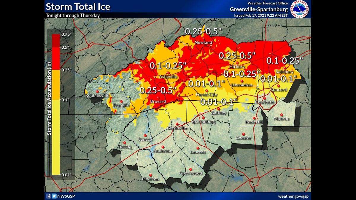
Uncertain storm movement
The biggest uncertainty with the storm is how far south the cold air will move, something that would increase the chances of “small ice accumulations” in Mecklenburg County, forecasters said earlier Wednesday.
Ice accumulations could be heaviest in such cities as Salisbury, Hickory and Statesville, according to meteorologists.
“Some trees and power lines will likely be brought down,” according to the NWS advisory. “Travel could be very difficult,” NWS forecasters said.
Duke Energy has more than 5,400 workers and contractors ready to respond to outages, according to the company.
“We urge customers to prepare for extended outages & make plans for elderly or those with special need,” company officials tweeted on Wednesday.
Heavy rain is expected in western North Carolina late Wednesday night through early Thursday afternoon and localized flooding is possible in areas along streams, officials said.
Rain chances in Charlotte should finally diminish to 40% on Friday, with cloudy skies expected Friday night and sunshine on Saturday.
This story was originally published February 17, 2021 at 5:59 AM.